Tim 45
|
| posted on 5/7/05 at 08:17 PM |

|
|
Better than NASA
Google earth. Has 3D buildings, and closer images than that of NASA, including a preset Area 51
Still in beta, and limited numbers available, search google earth in google or if your lazy clicky
[Edited on 5/7/05 by Tim 45]
 
|
|
|
|
|
Hellfire
|
| posted on 5/7/05 at 09:51 PM |
|
|
Jesus - I am impressed!

|
|
|
NigeEss
|
| posted on 5/7/05 at 10:01 PM |
|
|
Wow !
|
|
|
ayoungman
|
| posted on 6/7/05 at 08:28 AM |
|
|
Very good. The images arn't the highest resolution available. I remember seeing some last year where I zoomed in and could see my Landrover
outside my house ! A benefit of living near London !
When they mapped the country, they did London and the other cities to a greater detail depth.
"just like that !"
|
|
|
Mark Allanson
|
| posted on 6/7/05 at 06:28 PM |
|
|
In 3D mode, its incredible
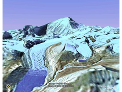 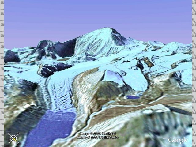
Rescued attachment Everest.jpg
If you can keep you head, whilst all others around you are losing theirs, you are not fully aware of the situation
|
|
|
wilkingj
|
| posted on 6/7/05 at 09:14 PM |
|
|
Yup,,,, Landsat is down to 1.0metre per Pixel. This means you can see Cars but not people. Landsat is a commercially run satellite.
So if a company can run a eye in the spy (or was it Sky?)
What do the Military and gov't spy sats run at resolution wise. You can bet your bottom dollar they can nearly count the hairs on your head,
assuming your are neither bald, or wearing a hat
I have played with Weather satellites for nearly 20 years ie tracking them using my aerials, and downloading the data and images. All quite legal as I
am registered with the ESA and the Euro met office etc etc.
My best picture, and I didnt realise it, I thought I had a memory malfunction, was a picture taken of a pass over Chernobyl. I got a HUGE BLACK BLOB
on my picture and scaling it up it was 100 miles or more in diameter. ALL BLACk was very hot (I have reverse Imagery then). I thought I had a
malfunction on my hardware computer... NO software, just decoded the signals and read them straight into the memory, then read the memory between the
write cycles and displayed it on the monitor.
This was Chernobyl Gone Bang... two days before it hit the papers / TV / Press.
I dont think we have ever been told the real truth about just how bad it was and how it affected us.
Anyway... getting away from the subject...
Yes they are WOW!!... and there is much better imaging stuff floating around up there!!.

1. The point of a journey is not to arrive.
2. Never take life seriously. Nobody gets out alive anyway.
Best Regards
Geoff
http://www.v8viento.co.uk
|
|
|
Mark Allanson
|
| posted on 6/7/05 at 09:18 PM |
|
|
I addicted to this thing now!
34°07' 55.48"N
118°19' 12.14"W
If you can keep you head, whilst all others around you are losing theirs, you are not fully aware of the situation
|
|
|
ethomas
|
| posted on 6/7/05 at 09:34 PM |
|
|
Try Keyhole
Keyhole contains all the data in Google Earth but it lets you fly around in a 3d rendered version in realtime.
It is the most amazing piece of software I have EVER used.
www.keyhole.com
Free trial, then $30 per year
|
|
|